Welcome to the Clouds thematic component of
METIS
!
METIS-Clouds
provides figures and diagnostics of current cloud (and
cloud-related) products, which are generated by
EUMETSAT operational processors.
. For a quick debrief on how to use this webpage. Please check the
Quickstart.
. Click on the images below
to see an animation of the latest processed data
|
Latest
Outgoing Longwave Radiation
(OLR)
data:
|
|
MTG/FCI
|
|
|
|
|
|
|
All
EUMETSAT
products can be reached at our
user portal
.
Do not hesitate to
contact us
if you need any infromation regarding any of these products.
The following table provides details regarding the
NRT
Level-2 Cloud and related data monitored in METIS-Clouds
| Instrument / Product_ID |
Orbit type |
Nadir FOV |
Frequency |
Parameters |
Data Access and Document
|
|
|
Geostationary |
~3 km |
1 disk every 15 min (3712 x 3712 pixels) |
|
|
| EO:EUM:DAT:MSG:CLM |
|
|
|
Cloud Mask |
CLM Data Web Page
|
| EO:EUM:DAT:MSG:CLA |
|
|
|
Cloud Phase, Cloud Top Pressure |
CLA Data Web Page
|
| EO:EUM:DAT:MSG:OCA |
|
|
|
Cloud Phase, Cloud Top Pressure, Cloud Optical Thickness, Cloud Effective Radius |
OCA Data Web Page
|
| EO:EUM:DAT:MSG:GII |
|
|
|
Total Precipitable Water |
GII Data Web Page
|
|
|
Geostationary |
~2 km |
1 disk every 10 min (5568 x 5568 pixels) |
|
|
| MTG / FCI / FCI-2-CLM |
|
|
|
Cloud Mask |
CLM Data Web Page
CLM Data Guide
|
| MTG / FCI / FCI-2-CT |
|
|
|
Cloud Phase |
PUG
CT Data Guide
|
| MTG / FCI / FCI-2-CTTH |
|
|
|
Cloud Top Pressure |
PUG
CTTH Data Guide
|
| MTG / FCI / FCI-2-OCA |
|
|
|
Cloud Phase, Cloud Top Pressure, Cloud Optical Thickness, Cloud Effective Radius |
OCA Data Web Page
OCA Data Guide
|
| MTG / FCI / FCI-2-GII |
|
|
|
Total Precipitable Water |
GII Data Web Page
GII Data Guide
|
| MTG / FCI / FCI-2-OLR |
|
|
|
Outgoing Longwave Radiation |
OLR Data Web Page
OLR Data Guide
|
|
|
Low Earth |
~1.1 km |
1 scan every 3 min (1080 x 2048 pixels) |
|
|
| EPS / AVHRR / EO:EUM:DAT:0200 |
|
|
|
Cloud Mask |
Daily Accumulated Cloud Data Web Page
Level 1BData Web Page
|
|
|
Low Earth |
~500 m |
1 scan every 1 min (840 x 3144 pixels) |
|
|
| EPS-SG / METimage / VII-02-CLD (TDPv2) |
|
|
|
Cloud Mask |
|
| EPS-SG / METimage / VII-02-CLD (TDPv2) |
|
|
|
Cloud Phase, Cloud Top Pressure, Cloud Optical Thickness, Cloud Effective Radius |
|
| EPS-SG / METimage / VII-02-CTP (TDPv2) |
|
|
|
Cloud Top Pressure, Cloud Optical Thickness |
TDPv2 Web Page
|
| EPS-SG / METimage / VII-02-WVI (TDPv2) |
|
|
|
Total Precipitable Water (Infra Red) |
|
| EPS-SG / METimage / VII-02-WVV (TDPv2) |
|
|
|
Total Precipitable Water (Visible) |
|
|
|
Low Earth |
~4 km |
1 overlap every 22 sec (185 x 573 pixels) |
|
|
| EPS-SG / 3MI / 3MI-02-CLD (TDPv2) |
|
|
|
Cloud Mask, Cloud Phase, Cloud Pressure, Cloud Optical Thickness, Cloud Effective Radius |
TDSv2 Web Page
|
|
|
Low Earth |
~100 m |
scan every 3 min (12857 x 3800 pixels) |
|
|
| CO2M / CLIM / S7A_CLI_2__ICM (TDPv2) |
|
|
|
Cloud Mask, Cloud Optical Thickness |
TDS Web Page
|
Products used in METIS-Clouds as reference
For cloud products:
Vertical profiles of cloud and turbulent properties at high temporal and spatial resolution from the ACTRIS network of ground-based stations, processed using the Cloudnet suite and distributed by the ACTRIS Data Centre node for cloud profiling (CLU) at the
Finnish Meteorological Institute (FMI).
For water vapour imagery products:
Radiosonde measurements from the
IGRA
network, GPS measurements from
SuomiNet
, and
EUMETNET data.
For outgoing long radiation data:
The NOAA Climate Data Record (CDR) of Daily Outgoing Longwave Radiation (OLR), Version 1.2 (
NOAA / CDR / OLR
)
and the Low latency (< 7 days from observations) combined Terra and Aqua FLASHFlux SSF globally gridded TOA and parameterized surface radiative fluxes for applied science uses (
CERES / FLASHFlux Level 3
).
Region of Interest (ROI)
ACTRIS stations
The up-to-date inventory of ACTRIS stations providing Cloutnet products is available at
FMI Cloudnet data portal
.
IGRA radiosonde
The IGRA up-tp-date station inventory is available at
IGRA Archive
SuomiNet GPS
The up-tp-date inventory of GPS sites registered in SuomiNet is available at
SuomiNet Registered Sites
EUMETNET
Information about EUMETNET data and campaigns is available at
EUMETNET Homepage
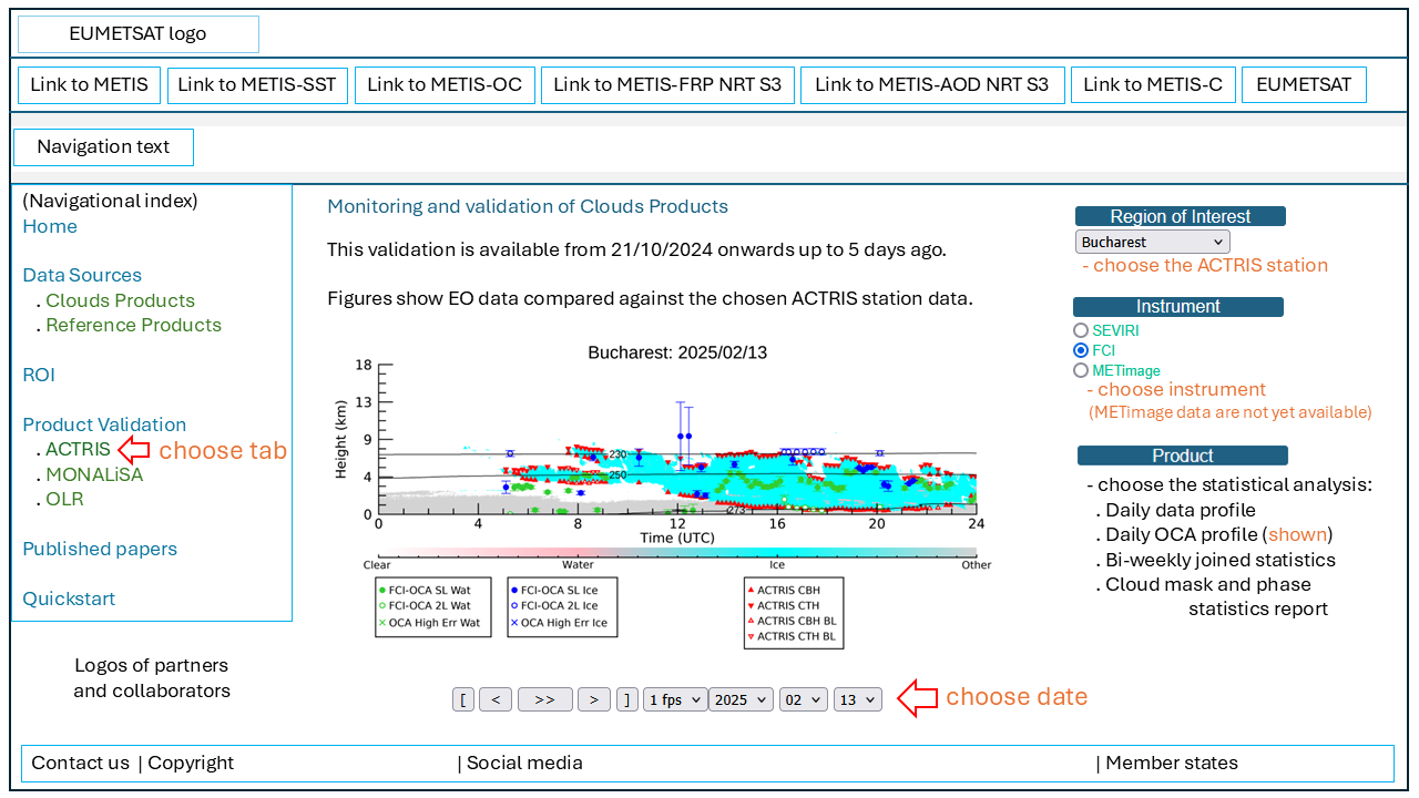
Monitoring and validation of
Clouds Products
(21/10/2024 onwards):
. Select a date at the bottom of the figure! (not all dates have all data options available!)
(You can click on the figures to make them bigger)
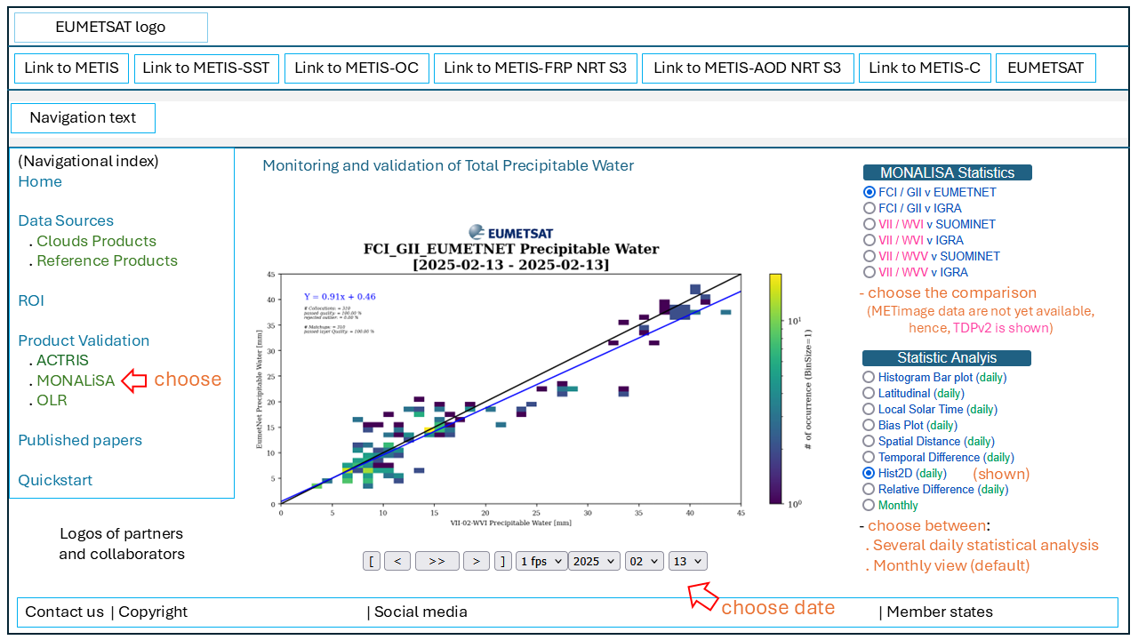
Monitoring and validation of
TPW
(for MONALiSA / METimage (VII) TDPv2 one example is shown per option)
. Select a date at the bottom of the figure! (not all dates have all data options available!)
(You can click on the figures to make them bigger)
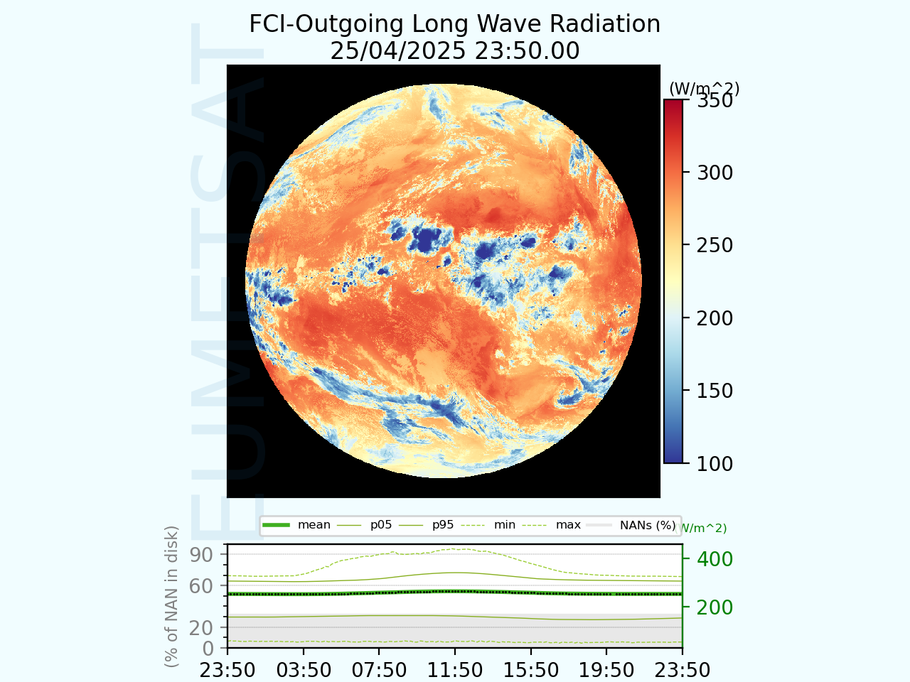
Monitoring and validation of
OLR
(This section is still under development. An example is shown)
. Select a date at the bottom of the figure! (not all dates have all data options available!)
(You can click on the figures to make them bigger)
Monitoring Cloud Mask products.
. Percentage of Cloudy pixels for all instruments.
. All variables of the SEVIRI/Cloud mask product.
. All variables of the FCI/Cloud mask product.
. All variables of the AVHRR/Cloud mask product.
Monitoring Cloud Phase products.
. Percentage of Water Cloud pixels for all instruments.
. All variables of the SEVIRI/OCA/Phase product.
. All variables of the FCI/OCA/Phase product.
. All variables of the SEVIRI/CLA/Phase product.
Monitoring Cloud Top Pressure.
. Mean of Cloud Top Pressure for all instruments.
. All variables of the SEVIRI/OCA/CTP product.
. All variables of the FCI/OCA/CTP product.
. All variables of the SEVIRI/CLA/CTP product.
Monitoring Cloud Optical Thickness.
. Mean of Cloud Optical Thickness for all instruments.
. All variables of the SEVIRI / COT product.
. All variables of the FCI / COT product.
Monitoring Cloud Effective Radius.
. Mean of Cloud Effective Radius for all instruments.
. All variables of the SEVIRI / CER product.
. All variables of the FCI / CER product.
Monitoring Total Precipitable Water.
. Mean of Total Precipitable Water for all instruments.
. All variables of the SEVIRI / TPW product.
. All variables of the FCI / TPW product.
Monitoring Outgoing Longwave Radiation.
. Mean of Outgoing Longwave Radiation for all instruments.
. All variables of the FCI / OLR product.
References
EUMETSAT Total Precipitable Water algorithm for the polar system - second generation (EPS-SG) visible/infrared imager (METimage)
, L. Spezzi, P. Watts, J. Jackson, 2017.
Study on O2 band Cloud Top Pressure retrieval with METimage
, HYGEOS and Laboratoire d'Optique Atmosphérique, Université de Lille/Sciences et technologies, 2015.
Retrieval of two‐layer cloud properties from multispectral observations using optimal estimation
, P. D. Watts, R. Bennartz, F. Fell, 2011.
An overview of the enhanced cloud and water vapour products from EUMETSAT new generation imagers
, L. Spezzi, A. Bozzo, J. Jackson, H. J. Lutz, A. B. Couto, P. Watts, T. August, B. Fougnie, B. Bojkov, 2023.
METIS – Clouds
, A. B. Couto, J. Jackson, H. J. Lutz, H. Bauch, A. Bozzo, L. Spezzi 2024
First Release of the Optimal Cloud Analysis Climate Data Record from the EUMETSAT SEVIRI Measurements 2004–2019
, A. Bozzo, M. Doutriaux-Boucher, J. Jackson, L. Spezzi, A. Lattanzio, P. D. Watts, 2024.
Remote sensing of cloud top pressure/height from SEVIRI: analysis of ten current retrieval algorithms
, U. Hamann, A. Walther, B. Baum, R. Bennartz, L. Bugliaro, M. Derrien, P. N. Francis, A. Heidinger, S. Joro, A. Kniffka, H. Le Gléau, M. Lockhoff, H.-J. Lutz, J. F. Meirink, P. Minnis, R. Palikonda, R. Roebeling, A. Thoss, S. Platnick, P. Watts, and G. Wind, 2014.
Validation activities for the level 2 geophysical products of the EUMETSAT Polar System-Second Generation (EPS-SG) visible/infrared imager (METimage)
, L. Spezzi, R. Borde, P. L. Phillips, P. Schlüssel, P. D. Watts, 2018.
Overview of calibration and validation activities for the EUMETSAT polar system: second generation (EPS-SG) visible/infrared imager (METimage)
, P. Phillips, R. Bonsignori, P. Schlüssel, F. Schmülling, L. Spezzi, P. Watts, I. Zerfowski, 2016.
The multi-viewing multi-channel multi-polarisation imager – Overview of the 3MI polarimetric mission for aerosol and cloud characterization
, B. Fougnie, T. Marbach, A. Lacan, R. Lang, P. Schlüssel, G. Poli, R. Munro, A. B. Couto, 2018.
The 3MI mission on-board EPS-SG: a multi-spectral multi-polarization multi-directional imager for operational characterization of aerosol and cloud
, B. Fougnie, T. Marbach, A. Lacan, P. Schluessel, R. Lang, G. Poli, R. Munro, 2018.
The 3MI mission: multi-viewing-channel-polarisation imager of the EUMETSAT polar system: second generation (EPS-SG) dedicated to aerosol and cloud monitoring
, T. Marbach, J. Riedi, A. Lacan, P. Schlüssel, 2015.
Cloud Algorithm Development Support Study Final Report
, University of Lille with support from HYGEOS-Earth Observation, 2019.
OPERATIONAL CLOUD MASKING FOR THE OSI SAF GLOBAL METOP/AVHRR SST PRODUCT
, L. Lavanant, P. M. L. Harang, J. Lelay, S. Péré, S. Philippe, 2007.
QuickStart
Welcome to
METIS-Clouds
QuickStart.
Here you can learn how to navigate through this webservice more efficiently.
Below, under the collapsibles, you can find diagrams explaing the web site structure.
General website structure
ACTRIS
(Cloud products) tab
MONALiSA
(Water Vapour products) tab